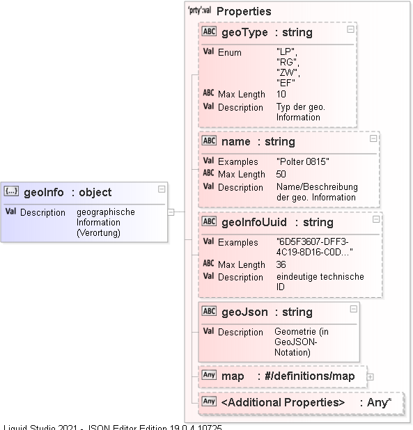
JSON Schema Definition 'geoInfo'
Description
geographische Information (Verortung)
Diagram
Value
Object
Properties
| Property Name | Type | Description |
|---|---|---|
| geoType | string | geoType (DRMDAT-01.json) |
| name | string | name (DRMDAT-01.json) |
| geoInfoUuid | string | geoInfoUuid (DRMDAT-01.json) |
| geoJson | string |
A String value
Description : Geometrie (in GeoJSON-Notation)
|
| map | object | map (DRMDAT-01.json) |
| Additional Properties | Type | Description |
| Any Property | Any | All values are valid, no restrictions. |
Source
"geoInfo": {
    "type": "object",
    "description": "geographische Information (Verortung)",
    "properties": {
        "geoType": {
            "type": "string",
            "description": "Typ der geo. Information",
            "enum": [
                "LP",
                "RG",
                "ZW",
                "EF"
            ],
            "maxLength": 10
        },
        "name": {
            "type": "string",
            "description": "Name/Beschreibung der geo. Information",
            "maxLength": 50,
            "examples": [
                "Polter 0815"
            ]
        },
        "geoInfoUuid": {
            "type": "string",
            "description": "eindeutige technische ID",
            "maxLength": 36,
            "examples": [
                "6D5F3607-DFF3-4C19-8D16-C0D00C3037D0"
            ]
        },
        "geoJson": {
            "type": "string",
            "description": "Geometrie (in GeoJSON-Notation)"
        },
        "map": {
            "$ref": "#/definitions/map"
        }
    },
    "required": [
        "geoJson"
    ]
}
C:\Users\Raimund Ziegler\Nextcloud4\Ziegler\EU-FHP\FHP DRM Digitales Rohstoffmanagement\Json\DRMDAT-01.json (466:10)
Documentation for DRMDAT-01
Generated using Liquid Studio 2021 - JSON Editor Edition 19.0.4.10725
Generated using Liquid Studio 2021 - JSON Editor Edition 19.0.4.10725